lunes, 30 de abril de 2012

El Templo Dorado de Amritsar // The Golden Temple of Amritsar

El Templo Dorado de Amritsar (o Harmandir Sahib) es una maravilla desde cualquiera de sus ángulos. Es el lugar más sagrado del sikhismo, practicado por 25 millones de personas, y se encuentra en la ciudad de Amritsar, provincia de Punjab en India y a a media hora de Pakistán.
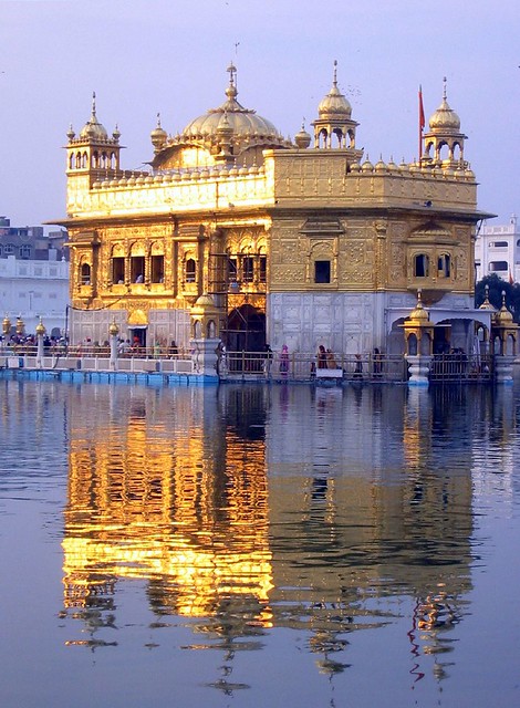
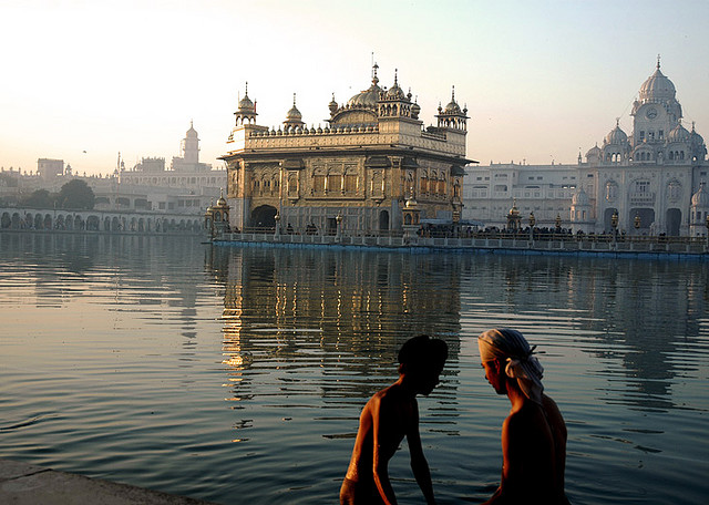
El templo dorado además de imponente, se refleja con elegancia en el agua de su entorno, ya que está construido sobre una plataforma en el estanque del amrit, precisamente para lograr ese efecto tan particular. El Templo dorado es el corazón de una plaza que rodea el estanque. Comenzado a construir en 1589 y terminado en 1601, es desde entonces el lugar más sagrado de ésta religión, al que además hay que peregrinar una vez en la vida. Recubierto con mármol, tanto el entorno de la plaza como el templo, la particularidad de Harmandir Sahib es su laminado en oro, y detalles dorados en sus cuatro puertas de acceso.
Las aguas sagradas del estanque también son utilizadas como un baño de purificación, con el encanto ser un sitio en el que habitan peces dorado que se acercan a los visitantes. La ciudad santa de Amritsar conmueve desde todos sus ángulos, y es una más de las maravillas tal vez no tan conocidas de India.

-

The Golden Temple of Amritsar (Harmandir Sahib or) is great from any angle. It is the holiest site of Sikhism, practiced by 25 million people and is located in the city of Amritsar in India Punjab province of Pakistan yaa half hour.
The Golden Temple in addition to imposing elegance is reflected in the water of their environment, as it is built on a platform in the pool of amrit, precisely to achieve that effect so special. The Golden Temple is the heart of a square surrounding the pond. Started building in 1589 and completed in 1601, has since become the most sacred of this religion, which also have to pilgrimage once in their life. Covered with marble, both the environment and the temple square, the particularity of Harmandir Sahib is the rolled gold and gold accents on all four doors.
The holy waters of the pond are also used as a purification bath, with the charm to be a place where fish live gold approaching visitors. The holy city of Amritsar moves from every angle, and is another of the wonders perhaps not so well known in India.

viernes, 27 de abril de 2012

Khumbu, cerca del cielo // Khumbu, close to the sky

Khumbu es la región nepalí del Monte Everest (una de las más visitadas de Nepal aunque no es un destino de fácil acceso). Habitada por el amable pueblo sherpa, es el “reino de las altísimas” montañas y de los paisajes sublimes, sumando cuatro de las catorce montañas más altas del planeta y una serie de picos que exceden por mucho los 7.000 metros. Podría decirse que es el mundo habitado “más cerca del cielo”.
Khumbu es tierra de monasterios budistas, pueblos con poco contacto con el mundo por miles de años, rutas en la montaña donde el mal de altura asedia a cualquier visitante foráneo, todo en el corazón del Himalaya. En suma, una región donde las alturas van desde los 3.300 hasta los 8.850 y donde es posible encontrar aldeas como Gorashep, a 5.175 m. de altura. De hecho, en Kumbu hay numerosos pueblos dispersos entre los que se destacan Ghat, Khumjung, Khunde, Lukla, Monju, Namche Bazaar (la puerta del Himalaya), Pangboche, Phortse, Tengboche, entre los más frecuentados por viajeros. También en ésta región se encuentra el Campamento base del Everest.
Recorrer la zona de Khumbu es tarea ardua por su escenografía abrupta.
La mejor época para visitar Khumbu es entre marzo y mediados de mayo, y desde septiembre a finales de noviembre cuando el clima es más estable y el paisaje se muestra en todo su esplendor, (aunque el trekking es posible durante todo el año). Siendo una región tan aislada y con un paisaje complicado, casi no hay carreteras, por lo que la mayoría de rutas de montaña se realizan a pie.

-

Khumbu is the Mount Everest region of Nepal (one of the most visited Nepal is a destination but not easily accessible). Inhabited by the friendly Sherpa people, is the "kingdom of the towering" mountains and stunning scenery, adding four of the fourteen highest mountains in the world and a series of peaks that far exceed the 7,000 meters. Arguably the inhabited world "closer to heaven."
Khumbu is a land of Buddhist monasteries, villages with little contact with the world for thousands of years, hiking in the mountains where altitude sickness plagues any foreign visitor, all in the heart of the Himalayas. In addition, a region where the heights ranging from 3,300 up to 8,850 and where it is possible to find villages like Gorashep to 5,175 m. height. In fact, there are numerous villages scattered Kumbu including highlights Ghat, Khumjung, Khunde, Lukla, Monju, Namche Bazaar (the door of the Himalayas), Pangboche, Phortse, Tengboche, the most frequented by travelers. Also in this region is the base camp of Everest.
Take the Khumbu area is an arduous task for its steep terrain.
The best time to visit Khumbu is between March and mid May and from September to late November when the weather is more stable and landscape shown in all its glory (although the trek is possible throughout the year). Being so remote a region with a complicated landscape, almost no roads, so most mountain roads are made on foot.

martes, 24 de abril de 2012

Coyote Buttes, olas de piedra // Coyote Buttes, waves of stone

La formación rocosa en arenisca, es sólo una parte de un paisaje increíble y mucho más extenso, modelado durante miles de años por el viento. En particular, ésta área llena de remolinos y olas de piedra se llama Coyote Buttes, y es un área restringida a la que sólo pueden entrar unas 20 personas al día luego de tramitar el permiso en la zona administrativa de un área protegida (Paria Canyon-Vermilion Cliff Wilderness) en el estado de Arizona. Incluso, llegar a descubrir éstos paisajes no es nada fácil sin algún guía experto, ni es raro regresar después de una larga caminata de 5 kilómetros sin poder encontrarlas.
Si bien la ola de Arizona es el paisaje más fotografiado, los remolinos de arenisca resultan aún más caprichosos por su conformación y sus franjas “espiraladas”.

-

The sandstone rock formation, is only part of an incredible landscape and more extensive modeling for thousands of years by wind. In particular, this area full of swirls and waves of stone called Coyote Buttes, and is a restricted area that can only get about 20 people a day after the permit process in the administrative area of ​​a protected area (Paria Canyon-Vermilion Cliff Wilderness) in the state of Arizona. Even get to discover these landscapes is not easy without some expert guidance, nor is it rare to return after a long walk 5 miles without being able to find them.
While the wave of Arizona is the most photographed scenery, sandstone swirls are even more capricious in its formation and its stripes
"spiral"
                                                                                                                               

viernes, 20 de abril de 2012

El impresionante Svalbard // Incredible Svalbard

Son las islas habitadas más septentrionales del mundo, es un desierto helado donde seis de cada 10 kilómetros cuadrado llevan siglos bajo la nieve y el hielo; el año sólo dura un día y una noche que se extienden por seis meses; los caminos tienen señales que anuncian el paso de osos polares. Nos trasladamos al norte de Europa para descubrir que las leyes naturales de Svalbard no se parecen a nada que podamos conocer. Pero además, a pesar su situación geográfica, las islas gozan de un clima relativamente benévolo gracias a la corriente del Golfo, lo que deja lugar a algunas sorpresas:
Svalbard, un archipiélago recluido en el Ártico, es una colección de curiosidades, en un territorio que aparenta no tener vida a simple vista y sin embargo está lejos de estar completamente desolado. En una de las ciudades de la isla, su nombre Longyearbyen es un curioso topónimo con un tinte de humor (una mezcla de inglés y noruego) que describe lo que puede significar vivir en el archipiélago: el lugar donde el año es muy largo. El tiempo parece transcurrir más lento.
Sus habitantes se definen como polárniks o polares, aunque en realidad, conviven en una inusual vecindad de rusos y noruegos, y en un territorio donde cualquiera puede instalarse sin necesitar visado ni permiso de residencia. Es un territorio en el que aparentemente, todos están invitados a llegar, y sin embargo, no llega casi nadie. Administradas por Noruega, aunque con bases rusas legalmente asentadas, Svalbard es un territorio inhóspito al que casi nadie llegaba por placer, hasta que en años recientes comienza a despuntar el turismo, que lentamente compite con la minería como la principal actividad económica.
En Svalbard están presente todos los tipos y formas de glaciares, y el color blanco de la nieve y el hielo. Cuando llega el verano, en las zonas habitadas todo se vuelve barro. El archipiélago debería permanecer completamente helado todo el año, pero lo salva la corriente del Golfo. Entonces, la nieve desaparece en las partes más bajas y suaves de las islas y aparecen grandes extensiones de tundra salpicadas a veces de flores.

-

They are the most northerly inhabited island in the world is a frozen desert where six of 10 square kilometers have spent centuries under the snow and ice year only lasts a day and a night that extend for six months, the roads have signs announce the passing of polar bears. We moved to northern Europe to discover the natural laws of Svalbard are unlike anything we know. In addition, despite its geographical location, the islands enjoy a relatively benign climate thanks to the Gulf Stream, which leaves room for some surprises:
Svalbard, an archipelago in the Arctic held, is a collection of curiosities, in a territory that appears to have no life to the naked eye, yet is far from being completely devastated. In one of the cities of the island, its name is a curious place name Longyearbyen with a tinge of humor (a mixture of English and Norwegian) describing what it might mean to live in the archipelago: the place where the year is too long. Time seems to pass more slowly.Its inhabitants are defined as polárniks or polar, but in fact, live in a rare neighborhood of Russians and Norwegians, and in an area where anyone can be installed without needing a visa or residence permit. It is an area where apparently, all are invited to come, and yet almost no one fails. Administered by Norway, although Russian bases legally settled, Svalbard is a territory inhospitable to almost no one came for pleasure, until in recent years tourism begins to dawn that slowly competes with mining as the main economic activity.

martes, 17 de abril de 2012

El valle de Lauterbrunnen // Lauterbrunnen's Valley

En Lauterbrunnen se halla en uno de los valles en U más impresionantes de los Alpes entre paredes rocosas gigantescas y altos picos de montaña. Con 72 cataratas impresionantes así como rincones acogedores, prados alpinos colorados y románticas posadas de montaña, el valle Lauterbrunnental es una de las reservas más grandes de Suiza.  
«Lauter Brunnen» ("solo fuentes") - el propio nombre del pueblo advierte sobre el carácter singular de este paisaje: en el valle Lauterbrunnental hay 72 cataratas. Un monumento característico es el Staubbachfall, que cae casi 300 metros a la profundidad desde una pared rocosa impresionante, una de las cataratas de caída libre más grandes de Europa. El poeta Johann Wolfgang von Goethe, que visitaba el valle en 1779, se hizo inspirar por las masas de agua, escribiendo el poema "Canto de los espíritus sobre las aguas". 
Otro espectáculo natural ensordecedor ofrecen las cataratas Trümmelbachfälle en el interior del montaña «Schwarzer Mönch», escondidas detrás de paredes rocosas impresionantes. Hasta 20.000 litros de agua caen cada segundo por los diez saltos de agua glaciares con una altura total de unos 200 metros. El espectáculo puede visitarse sólo en verano y con un teleférico de túnel.

-

In Lauterbrunnen is one of the most impressive valleys in U of the Alps between gigantic rock faces and mountain peaks. With 72 impressive waterfalls and cozy corners, colorful alpine meadows and romantic inns in the mountains, the valley Lauterbrunnental is one of the largest reserves of Switzerland.
'Lauter Brunnen' ('only sources ") - the very name of the town warns of the unique character of this landscape: in the valley has 72 waterfalls Lauterbrunnental. A landmark is the Staubbachfall, falling almost 300 meters depth from an impressive rock wall, one of the free-falling waterfall biggest in Europe. The poet Johann Wolfgang von Goethe, who visited the valley in 1779, was inspired by water bodies, writing the poem "Song of the Spirits over the Waters".
Another deafening natural spectacle offered by cataracts Trümmelbachfälle inside the mountain "Schwarzer Mönch", hidden behind impressive cliffs. Up to 20,000 liters of water fall every second of the ten waterfalls glaciers with a total height of 200 meters. The show can be visited only in summer and a cable car tunnel.

sábado, 14 de abril de 2012

El monte inaccesible de Saint-Michel // Saint-Michael, an inaccessible mount

El Monte Saint-Michel es una isla rocosa situada en la desembocadura del río Couesnon, en Francia. En la isla fue construido un santuario en honor del arcángel Saint Michel (San Miguel). La arquitectura prodigiosa del monte Saint-Michel y su bahía lo hacen el sitio turístico más concurrido de Normandía y uno de los destinos de viaje más concurridos de Francia con unos 3.200.000 visitantes cada año. Una estatua de San Miguel colocada en la cumbre de la iglesia abacial se erige a 170 metros por encima de la orilla.
Nombrado monumento histórico en 1987, el Monte Saint-Michel figura desde 1979 en la lista del patrimonio mundial de la UNESCO.
Una isla inaccesible: Las mareas espectaculares de la bahía contribuyeron mucho a hacer del monte una fortaleza inexpugnable, durante siglos únicamente era accesible por vía terrestre en los momentos de marea baja y por vía marítima cuando la marea era alta. Actualmente se puede acceder a la abadía en cualquier instante gracias a la carretera que llega a los pies de la roca.
 
-

The Mont Saint-Michel is a rocky island at the mouth of the river Couesnon, France. The island was built a shrine in honor of the archangel Saint Michel (St. Michael). The prodigious architecture of Mont Saint-Michel and its bay make it the most visited tourist site in Normandy and one of the busiest travel destinations of France with some 3,200,000 visitors each year. A statue of San Miguel placed at the top of the abbey church stands 170 meters above the shore.
Named a historic monument in 1987, the Mont Saint-Michel figure since 1979 in the list of UNESCO world heritage.
An Inaccessible Island: Tides spectacular bay much to make an impregnable fortress hill for centuries was accessible only by land in times of low tide and by sea when the tide was high. Currently you can access the abbey at any time thanks to the road leading to the foot of the rock.

jueves, 12 de abril de 2012

Ormuz, la isla hecha de sal // Ormuz, an island made of salt

En el medio de una de las zonas con los mayores recursos petrolíficos del planeta, hay una isla que tiene un toque especial. Su paisaje es árido, al punto de casi no mostrar vida a simple vista. En la isla de Ormuz (también conocida como Hormoz) no cae ni una gota de agua, lo que sumado al paisaje volcánico, hacen de la isla un lugar de altísima salinidad.
Situada en el estrecho de Ormuz, en la salida del Golfo Pérsico, la isla Ormuz pertenece a Irán y es parte del área que produce el 40% del petróleo mundial. La isla fue guarida de piratas durante siglos, y hasta fue ocupada por tropas coloniales portuguesas, que emplazaron un fuerte en el lugar. En una vista satelital, se puede ver esta isla dentro del estrecho de Ormuz.
El paisaje, hoy perdura como hace miles de años, cubierto de una capa volcánica y rocas sedimentarias, lo que le asigna un aspecto bastante inhóspito, y hasta diría, digno de algún planeta lejano.

-

In the middle of one of the areas with the greatest resources petrolíficos the planet, there is an island that has a special touch. The landscape is arid, to the point of almost not show life at a glance. On the island of Hormuz (Hormoz also known as) does not fall even a drop of water, which added to the volcanic landscape, make the island a place of high salinity.
Located in the Strait of Hormuz in the Persian Gulf output, the island belongs to Iran Hormuz and is part of the area that produces 40% of global oil. The island was lair of pirates for centuries, until it was occupied by Portuguese colonial troops, which emplaced a fort on the site. In a satellite view, you can see this island in the Strait of Hormuz.
The landscape remains today as thousands of years ago, covered with a layer volcanic and sedimentary rocks, which assigns a rather inhospitable, and to say, worthy of some distant planet.